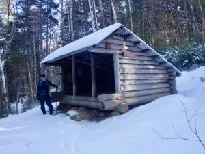
The Lean-tos
Leeman Brook • Wilson Valley • Long Pond Stream • Cloud Pond • Chairback Gap • Carl Newhall • Logan Brook • East Branch • Cooper Brook • Potawadjo Spring • Nahmakanta Stream • Wadleigh Stream • Rainbow Stream • Hurd Brook
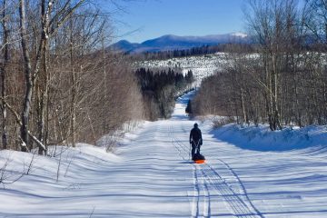
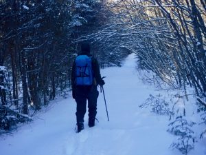
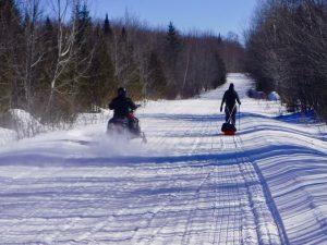
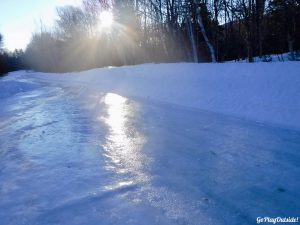
Pulling the pulk on the Frenchtown Rd. on the way to Logan Brook Shelter
The Challenge
After completing both the Winter Pinnacle Pursuit Challenge and the Maine Triple Twinter Challenge, Magoo and I were looking another winter challenge to set our sites on. We decided that we would attempt to visit every shelter of the 100 Mile Wilderness in winter. We will be doing this under our own power (no snowmobiles, although we have toyed with the idea of fat bikes to cross some of the longer lakes, I suspect we will stick to foot travel). We are not planning to do this as a single season challenge, although logistically it could certainly be done that way.
We do wonder if anyone has ever visited all of the 100 Mile Wilderness shelters in winter. There have been a few hikers who have done the 100 Mile Wilderness in winter conditions on attempts of winter SOBOs of the AT, but all started prior to December 21. The ones I know of are Trauma, The Real Hiking Viking, Greenleaf & Apple Pie, and Aquaman (There are likely others I do not know about). So even if they visited all the shelters when they passed through, it was not technically winter. This does not lessen their accomplishments in any way. What each of them did was amazing, and in our minds, a much greater challenge than we have planned.
That leaves one other group that I know of who have done the 100 Mile Wilderness in winter. They were not on a thru hike, and their trip was entirely within the technical dates of winter. They did report skiing on the lakes for some of the northern half to the trip. So, they may have bypassed some shelters in doing this.
If anyone knows of any others who have done this section in the winter, please, let me know.
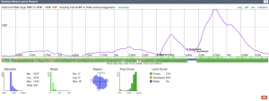
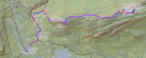
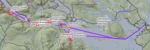
An example of the profile and terrain data available on the Caltopo maps
I have planned winter routes (sometimes multiple routes) to all of the shelters using caltopo. I have provided links to all of these maps. From these maps you can export the gps tracks and gather a wealth of information including the profile and terrain data. All of these routes have inherent risks and dangers. We assume no responsibility for others using these routes. They are offered so that others might be able to offer suggestions to our proposed routes.
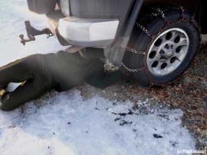
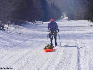
Chaining up!
We have also posed questions below (often about parking) with many of the routes. If anyone has any answers to any of these questions, please let us know! You can either post your answers near the bottom of this page or email me.
All distances are one-way. Double the mileage for round trip.
Leeman Brook Lean-to
Status: Complete (01/23/21)
Shelter Elevation: 1055’
Route A
3.02 total: 3.02 trail
Elevation gain: 468’; Elevation loss: 628’ • Elevation Range: 1047’ – 1424’
Parking
The AT parking lot on route 15 is not typically plowed, although sometimes it is plowed for the first early snow or two. For parking purposes this would best be done when there is little snow so that the lot can be accessed.
Notes
Access is entirely by trail on the AT. It could be done in any snow conditions. The trail close to the shelter has several short but steep ledges. If there is a lot of ice those sections could be tricky, especially the ravine just before the shelter. There are a couple of stream crossings which at most times should be passable. High water could make them difficult. The trail is only exposed for a few short walks around ponds. Wind direction is not much of a consideration.
The North Pond Rd. Might be a possible escape route. Where this road meets the Elliotsville Rd. there is a gate and multiple signs posting the road as private.
Questions
None
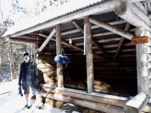
Wilson Valley Lean-to 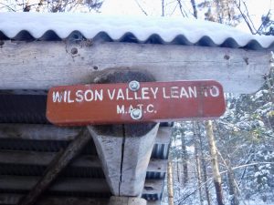
Status: Complete (01/08/22)
Shelter Elevation: 975’
Route A
1.86 total: 1.10 road, 0.76 trail
Elevation gain: 510’; Elevation loss: 365’ • Elevation Range: 833’ – 1179’
Parking
In low snow you could snowbank a vehicle where the Slate Rd. leaves the Mountain Rd. The Borestone parking area isn’t always plowed, many times there has been enough winter traffic there to keep a place or two accessible to parking. Parking at the Borestone lot adds one mile to the distance.
On Slate Rd. heading toward Wilson Valley Lean-to
Notes
Could be done in any conditions. Short mileage divided between a tote road and the AT. Not much exposure. Wind not much of a concern.
Questions
None
Long Pond Stream Lean-to
New Year’s Eve 2021!
Status: Complete (12/31/21)
Shelter Elevation: 911’
Route A
2.33 total: 1.45 road, 0.88 trail
Elevation gain: 518’; Elevation loss: 191’ • Elevation Range: 541’ – 1004’
Parking
If there is no snow you can drive all the way to the trailhead with parking. If low snow, you can drive on unplowed section for a quarter mile and park before the bridge. Unknown if parking is available at higher snow levels. There is a snowplow turn around that is very clearly marked as no parking. Starting at the Borestone parking would add an additional 2 miles. Borestone parking is not always plowed in the winter.
Notes
Could be done in most any conditions. Parking concerns will dictate conditions more than the hiking. The walked road is wide enough that you will have some exposure to the wind.
Questions
None
Cloud Pond Lean-to
Route Map • Trip Report
Status: Not yet attempted
Shelter Elevation: 2415’
Route A
5.66 total: 1.49 road, 3.78 trail, 0.13 bushwhack, 0.26 lake
Elevation gain: 2272’; Elevation loss: 466’ • Elevation Range: 541’ – 2637’
Parking
If there is no snow you can drive all the way to the trailhead with parking. If low snow, you can drive on unplowed section for a quarter mile and park before the bridge. Unknown if parking is available at higher snow levels. There is a snowplow turn around that is very clearly marked as no parking. Starting at the Borestone parking would add an additional 2 miles. Borestone parking is not always plowed in the winter.
Notes
Either bare trail or enough snow to use snowshoes would be preferred. Route A requires that Cloud Pond is frozen. Could be done on any wind. North wind would be best, south worst. If there is no snow at lower elevations the road portion could be driven. Road is windy, steep, and not well plowed from Borestone parking to a quarter mile before the bridge and gate.
Questions
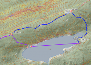
On-trail and off-trail options for Cloud Pond Lean-to
Is the bushwhack and pond crossing worth it? It is only marginally shorter, but the pond travel would be quicker and easier than the trail. If the bushwhack is thick and difficult it would negate any advantages. Assess the terrain when near the cut off.
Is parking available at higher snow levels? See parking notes.
Post your answers near the bottom of this page or email me.
Chairback Gap Lean-to
Route Map • Trip Report
Status: Not yet attempted
Shelter Elevation: 1983’
Route A
5.28 total: 4.19 road, 0.91 bushwhack, 0.18 trail
Elevation gain: 1579; Elevation loss: 181’ • Elevation Range: 581’ – 2051’
Parking
I’ve been told the road gets plowed into the KI checkpoint and that parking is available here.
Notes
Much of the bushwhack is through a fan of skidder cut roads. Steepest terrain appears to be in the second half of this section. Having enough snow for snowshoes may help to smooth out the footing in the choppings.
Wind direction is worth attending to with a NW wind being ideal and SE less so.
Questions
Is the KI in fact plowed into the checkpoint and is parking available there?
Is there heavy snowmobile traffic on this route?
Post your answers near the bottom of this page or email me.
Route B
8.72 total: 4.51 road, 0.41 trail, 3.21 lake, 0.59 bushwhack
Elevation gain: 1007’; Elevation loss: 484’ • Elevation Range: 1112’ – 1991’
Parking
Winter parking on Greenville side of the KI Rd.
Notes
AMC hut over half way through this route. Bushwhack route does not appear to have any old roads to utilize. It has been plotted to stay in what appears to be hardwood forests as much as possible.
Questions
Is there a better bushwhack route to make use of?
Post your answers near the bottom of this page or email me.
Carl Newhall Lean-to
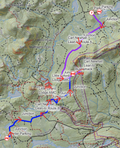
Status: Failed Attempt 2/20/22 – 2/21/22
Shelter Elevation: 1893’
Route A
7.48 total: 6.00 road, 0.62 bushwhack, 0.36 overgrown logging road, 0.50 difficult bushwhack
Elevation gain: 910’; Elevation loss: 527’ • Elevation Range: 1394’ – 1978’
Parking
There is typically enough space at the bottom of the hill after the turn off to West Branch Camps to park. Parking a bit before the turn off to the camps would be better.
Notes See notes section of route B below for details about the bushwhack these two routes share
In the past, the Frenchtown Road has been plowed by the county up to the end of First Roach Pond and then privately plowed until the bottom of the hill just past the turn to West Pond Camps. Road can get soft during a thaw.
The bushwhack is designed to first travel through hardwoods, then connect to an old tote road for a bit. The final portion of the bushwhack may be through thicker evergreens. It has been routed around and between some possible ledge drops.
Any exposure to the wind would be on the road which runs NE/SW.
Questions
Is there any parking before West Branch Camps?
Post your answers near the bottom of this page or email me.
Route B (Failed Attempt 2/20/22 – 2/21/22)
8.36 total: 5.58 groomed trail, 2.28 overgrown logging road, 0.50 difficult bushwhack
Elevation gain: 1211’; Elevation loss: 814’ • Elevation Range: 1151’ – 1977’
Parking
Winter parking on Greenville side of the KI Rd. There is a large parking area. We were there on a holiday weekend. Parking was still available but was down to a handful of spots
Notes
Multiple road intersections to navigate. The bushwhack may be through thicker evergreens. It has been routed around and between some possible ledge drops.
 Since the early portion of the trail is groomed, navigating the intersections is pretty straight forward. Travel is easy and fast.
Once you turn off onto the ungroomed old logging road travel slows significantly. The first mile of this section is a tangle of alders. We managed to pull our pulks through here but it was slow and tiring.
The second mile of the old logging road is steep. It looks like a ski trail cut straight up the ridge. The alders are gone at this point. Instead this section is overgrown with small fir and spruce. This creates a minefield of spruce traps. We both got caught by three or four of these spruce traps. Getting caught in these wearing snowshoes and a pulk make extrication difficult and exhausting.
 We were burning a too much daylight in this section. We decided to leave the pulks on trail, to attempt a quicker tag of the shelter and then return and set up camp.
Travel was quicker without the pulks, but not by much. Some places the spruce traps were so thick it was easier to bushwhack off to one side of the logging road.
 When the logging road ends, the .5 mile bushwhack begins. The bushwhack is through thick woods and there are numerous ledge drops. This makes staying on a gps track impossible and progress slow and laborious. It became clear very quickly that we were not going to be able to get to the shelter on this trip. We had to turn around after having travelled 8 miles. We were only .5 of a mile from the shelter.
Though frustrating, I estimate it could take up to 3 hours to be able to find a route through that bushwhack and then another hour or two back out.
Route A shares this same bushwhack section. I have plotted a Route C based on what we learned on this attempt. I will post that here once the map is complete.
Questions
None
Route C
8.84 total: 5.58 groomed trail, 1.27 overgrown logging road, 0.15 bushwhack, 1.84 trail
Elevation gain: 1199’; Elevation loss: 772’ • Elevation Range: 1151’ – 1926’
Parking
Winter parking on Greenville side of the KI Rd.
Notes
Old logging road has a long alder thicket that is slow to travel through. Two unbridged stream crossings. Should not be done after rain or thaw. Best after cold stretch to increase the chance of ice bridges. See notes on failed attempt of Route B. Route C departs Route B before the spruce trap section.
Questions
None
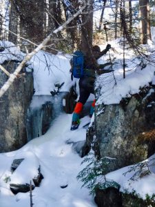
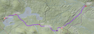
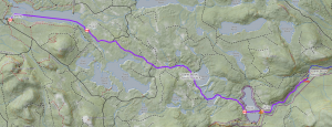
Logan Brook Lean-to
Status: Complete (03/17/19)
Shelter Elevation: 2394’
Route A
4.78 total: 3.34 road, 0.52 bushwhack, 0.92 trail
Elevation gain: 1033’; Elevation loss: 138’ • Elevation Range: 1476’ – 2394’
Parking
There is typically enough space at the bottom of the hill after the turn off to West Branch Camps to park. Road in can get soft during thaws.
Notes
In the past, the Frenchtown Road has been plowed by the county up to the end of First Roach Pond and then privately plowed until the bottom of the hill just past the turn to West Pond Camps. Road can get soft during a thaw.
The bushwhack is designed to travel through hardwoods and connect to the AT. This cuts out some road walk and avoids the early steeper section of the AT.
Questions
None
East Branch Lean-to
Route Map • Trip Report
Status: Not yet attempted
Shelter Elevation: 1247’
Route A
5.74 total: 3.82 road, 1.92 trail
Elevation gain: 328’; Elevation loss: 587’ • Elevation Range: 1247’ – 1646’
Parking
Icy parking at the end of the plowed portion of the Frenchtown Rd.
There is typically enough space at the bottom of the hill after the turn off to West Branch Camps to park. Road in can get soft during thaws.
Notes
In the past, the Frenchtown Road has been plowed by the county up to the end of First Roach Pond and then privately plowed until the bottom of the hill just past the turn to West Pond Camps.
Questions
None
Cooper Brook Lean-to
Route Map • Trip Report
Status: Not yet attempted
Shelter Elevation: 913’
Route A
14.08 total: 3.11 lake, 8.01 road, 0.57 lake, 2.39 trail
Elevation gain: 399’; Elevation loss: 769’ • Elevation Range: 913’ – 1419’
Parking
Plowed parking at the Medawisla AMC lodge. Road in can get soft during thaws.
Notes
This is a long route. Probably could be done in two days but may be best to be prepared for three. Should be able to bring pulks the whole way, may be slow pulling after mile 11.67 on the AT.
Questions
This a long route. Is there a better way to access this shelter in the winter?
The Turkey Tail route is 16.71 miles. If the road is plowed more that three miles in and there is parking this route may be worth considering. Is the Turkey Tail Rd. plowed? If so, how far? Is parking available?
The Jo-Mary Rd. route is 15.23 miles. Is logging happening in the winter? Is vehicle travel permitted? Is there parking? Is foot traffic permitted?
There is a +13 mile route from the Frenchtown Rd. to the AT. This route would involve more trail miles, a somewhat significant stream crossing, and travel over Little Boardman Mountain. Although slightly shorter, travel would be slower and pulling pulks could be challenging.
Post your answers near the bottom of this page or email me.
Potawadjo Spring Lean-to
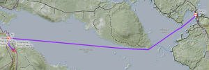
Route Map • Trip Report
Status: No attempt
Shelter Elevation: 619’
Route A
(to Ambajejus Lake boat launch. This is the return route from the three day trip.)
9.60 total: 8.91 lake, 0.69 trail
Elevation gain: 10’; Elevation loss: 135’ • Elevation Range: 489’ – 622’
Route B
(from Nahmakanta Stream Lean-to. See Wadleigh Stream Lean-to map.)
4.36 total: 0.34 bushwhack, 2.60 road, 0.73 lake, 0.69 trail
Parking
At Ambajejus Lake boat launch.
Notes
This will mostly likely be completed as a part of a three day trip which would include travel to Nahmakanta Stream Lean-to, and Wadleigh Stream Lean-to. See the Wadleigh Stream Lean-to map for this route.
Lots of exposure on long lake crossing. Low winds preferred. Temperatures below freezing preferred to avoid slush on lake.
Questions
Is there plowed parking at Ambajejus Lake boat launch? Is overnight parking permitted? How much snowmobile traffic is on Ambajejus and Pemadumcook Lake? Is there a better route to access this shelter in the winter?
Post your answers near the bottom of this page or email me.
Nahmakanta Stream Lean-to
Route Map • Trip Report
Status: Not yet attempted
Shelter Elevation: 535’
Route A
11.94 total: 9.00 lake, 2.60 road, 0.34 bushwhack
Elevation gain: 120’; Elevation loss: 76’ • Elevation Range: 489’ – 559’
Parking
At Ambajejus Lake boat launch.
Notes
This will mostly likely be completed as a part of a three day trip which would include travel to Potawadjo Spring Lean-to, and Wadleigh Stream Lean-to. See the Wadleigh Stream Lean-to map for this route.
Lots of exposure on long lake crossing. Low winds preferred. Temperatures below freezing preferred to avoid slush on lake.
Questions
Is there plowed parking at Ambajejus Lake boat launch? Is overnight parking permitted? How much snowmobile traffic is on Ambajejus and Pemadumcook Lake? Is there snowmobile traffic on any other part of our route? Is there a better route to access this shelter in the winter?
Post your answers near the bottom of this page or email me.
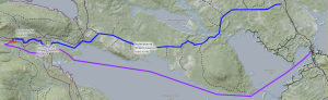
Wadleigh Stream Lean-to
Route Map • Trip Report
Status: Not yet attempted
Shelter Elevation: 675’
Route A
(From Nahmakanta Stream Lean-to):
5.22 total: 0.34 bushwhack, 1.17 road, 0.40 bushwhack, 1.25 trail, 1.85 lake, 0.21 bushwhack
Elevation gain: ; Elevation loss:
Parking
At Ambajejus Lake boat launch.
Notes
Unless I have missed a more obvious route, this appears to be the most difficult shelter to access in the winter.
This will mostly likely be completed as a part of a three day trip which would include travel to and base camp at Nahmakanta Stream Lean-to, and Potawadjo Spring Lean-to.
Lots of exposure on long lake crossing. Low winds preferred. Temperatures below freezing preferred to avoid slush on lake.
Questions
Is there plowed parking at Ambajejus Lake boat launch? Is overnight parking permitted? How much snowmobile traffic is on Ambajejus and Pemadumcook Lake? Is there snowmobile traffic on any other part of our route? Is there a better route to access this shelter in the winter?
Post your answers near the bottom of this page or email me.
Rainbow Stream Lean-to
Route Map • Trip Report
Status: Not yet attempted
Shelter Elevation: 1022’
Route A
4.75 total: 2.78 road, 0.53 bushwhack, 0.13 lake, 1.31 bushwhack
Elevation gain: 536’; Elevation loss: 528’ • Elevation Range: 1007’ – 1316’
Parking
Does anyone know what these building are?
Unknown. Hoping there is winter parking on the Golden Rd. Satellite images show a cluster of buildings .2 of a mile south of here. Perhaps somewhere to park there.
Notes
Unknown parking situation. If done in low snow, could perhaps shovel out a spot. Long bushwhack. Route has been designed to pass through some cuts that appear on satellite images. Route through cuts may be easier when there is enough snow for snowshoes.
Questions
Is parking available?
Is the Golden Rd. plowed through this section?
How is travel through the cuts?
What are the buildings .2 to the south?
Post your answers near the bottom of this page or email me.
Route B
7.98 total: 0.20 road 3.03 trail, 3.06 lake, 0.06 trail, 0.09 bushwhack, 0.85 lake, 0.34 trail, 0.23 lake, 0.12 bushwhack
Elevation gain: 851’; Elevation loss: 436’ • Elevation Range: 607’ – 1316’
Parking
Unknown. Hoping there is winter parking on the Golden Rd. near Horserace camping area.
Notes
Some logistical trickiness here. First is unknown parking situation. If done in low snow, could perhaps shovel out a spot. The distance is a long single day. For an overnight, the first trail section may be slow pulling for pulks. May be best to be able to transition between carrying gear on back and in pulk.
There are also lots of short transitions in the second portion hopping from pond to pond by combinations of trails and bushwhacks. These transitions are often near inlets and outlets so attention needs to be paid to the ice conditions.
Wind exposure on the lakes. No obvious preferred wind direction.
Questions
Is winter parking available on the Golden Rd. near Horserace camping area?
Is the Golden Rd. plowed through this section?
Post your answers near the bottom of this page or email me.
Hurd Brook Lean-to
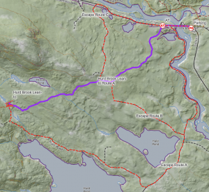
Route Map • Trip Report
Status: Complete (03/05/22)
Shelter Elevation: 707’
Route A
3.28 total: 3.28 trail
Elevation gain: 567’; Elevation loss: 899’ • Elevation Range: 567’ – 899’
Parking
Near Abol Bridge.
Notes
Overall, looks like an easy trip that could be done in a variety of conditions. No lake crossings, no bushwhacks, no exposure, except for a short walk on Golden Rd.
Questions
None.